9.7 km | 11.7 km-effort
la Bazoge
xst
User
Length
15.9 km
Max alt
163 m
Uphill gradient
280 m
Km-Effort
19.6 km
Min alt
73 m
Downhill gradient
280 m
Boucle
Yes
Creation date :
2019-01-15 19:55:58.732
Updated on :
2019-01-15 19:55:58.732
2h18
Difficulty : Easy
FREE GPS app for hiking
About
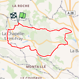
Trail Mountain bike of 15.9 km to be discovered at Pays de la Loire, Sarthe, La Chapelle-Saint-Fray. This trail is proposed by xst.
Description
rando cheval facile. Départ: terrain de foot de la Chapelle Saint Fray.
Positioning
Country:
France
Region :
Pays de la Loire
Department/Province :
Sarthe
Municipality :
La Chapelle-Saint-Fray
Location:
Unknown
Start:(Dec)
Start:(UTM)
283156 ; 5333739 (31U) N.
Comments
Trails nearby
la chapelle/la bazoge
Horseback riding
Medium
(1)
La Chapelle-Saint-Fray,
Pays de la Loire,
Sarthe,
France
20 km | 25 km-effort
3h 9min
Yes
Circuit du Roussard - La Bazoge
Mountain bike
Medium
La Bazoge,
Pays de la Loire,
Sarthe,
France
23 km | 28 km-effort
1h 10min
Yes
La Bazoge
Walking
Very easy
(2)
La Bazoge,
Pays de la Loire,
Sarthe,
France
15.5 km | 18.9 km-effort
Unknown
Yes
Mézières-sous-Lavardin
Walking
Very easy
Mézières-sous-Lavardin,
Pays de la Loire,
Sarthe,
France
12.7 km | 15.7 km-effort
Unknown
Yes
Sainte-Sabine-sur-Longève
Walking
Easy
(1)
Sainte-Sabine-sur-Longève,
Pays de la Loire,
Sarthe,
France
9.9 km | 12 km-effort
2h 0min
Yes
Maquere 10km
Cycle
Very easy
Aigné,
Pays de la Loire,
Sarthe,
France
11.2 km | 13.4 km-effort
Unknown
Yes
Mezières 1
Mountain bike
Easy
Mézières-sous-Lavardin,
Pays de la Loire,
Sarthe,
France
15.5 km | 18.5 km-effort
1h 28min
Yes
Méziére
Nordic walking
Very easy
Mézières-sous-Lavardin,
Pays de la Loire,
Sarthe,
France
10.5 km | 12.9 km-effort
2h 36min
Yes